
campbellford
Ontario's Clean Water Act requires the establishment of regional Source Protection Committees that must develop local science-based protection policies to safeguard water sources in vulnerable areas.
Campbellford is the largest centre within the municipality of Trent Hills, found in Northumberland County. It is located on the Trent-Severn Waterway and is part of the Lower Trent Source Protection Area, whose Source Protection Committee is actively encouraging public input into the development of a source protection plan. (see the Proposed Trent Assessment Report's map of the Lower Trent Source Protection Area Watershed Boundaries). This plan will include policies and programs intended to protect water sources and will be implemented following approval by the Ontario Ministry of the Environment.
Information below is taken from the Proposed Trent Assessment Report. This Report had not yet been approved by the Ontario Ministry of the Environment when the information below was posted here in March of 2011. As such, information shown on this page may be subject to change. For current information please go to: www.trentsourceprotection.on.ca.
Campbellford's Source of Drinking Water
The source of Campbellfords drinking water is the Trent River.
Residents of Campbellford acquire their drinking water after it is treated at the Campbellford Water Treatment Plant. Approximately 3,300 residents are serviced by the water treatment system.
Intake Protection Zones
Protecting the area around a surface water intake means protecting the surrounding water and, in most cases, the land that surrounds the water. This area of water and land is known as an intake protection zone (IPZ). The size of an IPZ is determined by the time that it takes for a material spilled in or near the water to flow into the water intake pipe. (see more info below the map)
Click on the map below to enlarge
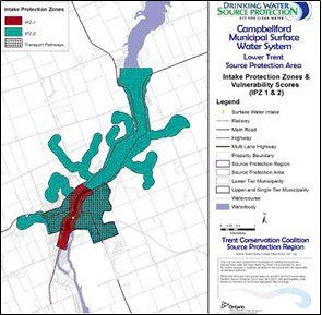
Map 4-11a: Campbellford Intake Protection Zones (IPZ 1 & 2) from the Proposed Trent Assessment Report
In Ontario, Intake Protection Zones are separated into three categories:
- IPZ-1: The area immediately adjacent to the intake. This zone is considered the most vulnerable since any contamination would have little opportunity for being diluted before reaching the intake. It is usually a 1-km radius around the intake with a setback on land of 120 metres from the shoreline.
- IPZ-2: An area upstream where a spill might reach the intake pipe before the plant operator can react (minimum time of 2 hours) (IPZ-2)
- IPZ-3: A larger part of the watershed where contaminants might find their way into the intake pipe; this zone may be impacted by extreme events such as storms, strong winds, or high waves.
Threats to Drinking Water Quality
Given that Campbellford is an urban centre, the land cover (including many paved surfaces) is very impermeable and so runoff is a potential source of concern for water quality.
Activities that contribute to drinking water issues are considered drinking water threats. A number of threats to drinking water quality have been identified in the Proposed Trent Assessment Report. (see Table 4.4-4 on page 4-63 of the Proposed Trent Assessment Report).
Significant threats for surface water in the Campbellford area include:
- the storage of agricultural source material
- the application, handling and storage of pesticides
- the application of road salt
- the handling and storage of fuel
Take Action
Learn how you can support your sources of drinking water, including how to dispose of your household hazardous wastes.
Source and for more information:
Proposed Trent Assessment Report