
burlington
Ontario's Clean Water Act requires the establishment of regional Source Protection Committees that must develop local science-based protection policies to safeguard water sources in vulnerable areas.
The City of Burlington is part of the Halton-Hamilton Source Protection Region, whose Source Protection Committee is actively encouraging public input into the development of a source protection plan. This plan will include policies and programs intended to protect water sources and will be implemented following approval by the Ontario Ministry of the Environment. See a map of the Halton Region Source Protection Area.
Information below is taken from the Proposed Assessment Report for the Halton Region Source Protection Area and was posted on March of 2011. At this time the Report had not yet been approved by the Ontario Ministry of the Environment. As such, information shown on this page may be subject to change. For current information please go to: www.protectingwater.ca.
Burlington's Source of Drinking Water
The nearshore zone of Lake Ontario supplies the source drinking water for the City of Burlington. Two Intake pipes draw water from the lake. The water that is drawn is pumped to a treatment plant. The Burlington water supply intake is located approximately 4.8 kilometres from the Burlington Canal (see map below). Approximately 97% of city residents rely on this municipal water supply.
Intake Protection Zones
Protecting the area around a surface water intake means protecting the surrounding water and, in most cases, the land that surrounds the water. This area of water and land is known as an intake protection zone (IPZ). The size of an IPZ is determined by the time that it takes for a material spilled in or near the water to flow into the water intake pipe. (see more info below the map)
Click on the map below to enlarge
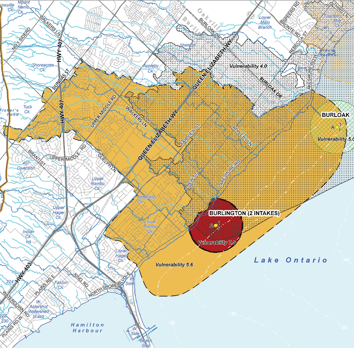
Burlington's IPZ 1 & 2
Taken from p.136 of the Proposed Assessment Report for the Halton Region Source Protection Area
In Ontario, Intake Protection Zones are separated into three categories:
- IPZ-1 (Red on the map): The area immediately adjacent to the intake. This zone is considered the most vulnerable since any contamination would have little opportunity for being diluted before reaching the intake. It is usually a 1-km radius around the intake with a setback on land of 120 metres from the shoreline.
- IPZ-2 (Orange on the map): An area upstream where a spill might reach the intake pipe before the plant operator can react (minimum time of 2 hours) (IPZ-2)
- IPZ-3: A larger part of the watershed where contaminants might find their way into the intake pipe; this zone may be impacted by extreme events such as storms, strong winds, or high waves.
Take Action
Learn how you can support your sources of drinking water, including how to dispose of your household hazardous wastes.
Source and for more information:
Download the Proposed Assessment Report for the Halton Region Source Protection Area
Download our Lake Ontario: Yours to Drink brochure